Showing posts with label GPS. Show all posts

Wednesday, December 8, 2010

Download Lookator Android. Scans Wi-Fi with Augmented Reality

Download Lookator Android. Scans Wi-Fi with Augmented Reality


Overview :Lookator is an Augmented Reality app for finding better WiFi signals. A whole new way to search for W-Fi networks nearby you. Open it, hold up your phone and you’ll see hotspots around you with their relative strength and direction.

What does Lookator do? When you launched the app it open the phone’s camera as well and shows any available networks overlayed on the screen. It also gives you the signal strength for every networks so you can chose the strongest one.

Enable GPS and download Wefi to get hotspots out of range too! Directions may not lead exactly to a hotspot – but it will lead to better signal
Lookator was developed for Android by LoFT

Requirements : Android
Download:
http://www.megaupload.com/?d=TWV6M9FI
Please Post Your Suggestions.

Read More!

Sunday, December 5, 2010

Ulysse Gizmos Android Download v1.5.2 Best tool set on Android for Travel.

Ulysse Gizmos Android Download v1.5.2 Best tool set on Android for Travel.


Overview :
Ulysse Gizmos is the best set of tools to help you in a travel with your Android phone. Ulysse Gizmos features:
- Compass;
- Speedometer;
- GPS status;
- Bubble level;
- Clinometer;
- Magnetometer;
- Map view;
- Location/waypoint address;
- Location/waypoint exchange;
Ulysse Gizmos was developed for Android by binarytoys

Requirements : Android
Download:
http://www.megaupload.com/?d=C7TOTHN0
Please Post Your Suggestions.

Read More!

Friday, December 3, 2010

Wireless File Transfer Android Download v0.4.1a

Wireless File Transfer Android Download v0.4.1a


Overview : Wireless File Transfer App for Android lets you easily transfer files between device and computer without any wire. Just enter a address into web browser, you can view, upload and download files to and from the phone. It also features one-click-install which simply install app from web browser.

Requirements : Android
Download:
http://www.megaupload.com/?d=X9W21RVK
Please Post Your Suggestions.

Read More!

Thursday, December 2, 2010

GPS Restore for Samsung vibrant and captivate (gps fix)

GPS Restore for Samsung vibrant and captivate


Overview
:Samsung releases 'GPS Restore' app for Captivate and other Galaxy S models

Seems Samsung still hasn't solved the GPS woes on many of its Galaxy S models to the satisfaction of every user -- complaints of inordinately long times continue to trickle into our inbox to this very day. To that end, folks might be interested in the news that Samsung Mobile is tweeting about a "GPS Restore Application" that it's thrown together for wiping the GPS subsystem and making it factory-fresh. Now, we'll be the first to admit -- we don't quite understand how "restoring" a screwed-up GPS to its original screwed-up state is doing any good, but we'll leave it to Sammy's confusing verbiage:

"During online surveillance, there is an abundance of GPS tweaks that impair GPS performance. Often times, no backup is performed to restore values prior to modifications. Samsung has released an application that restores GPS settings to recommended factory defaults for optinum [sic] performance."

Right, then. It's only compatible with the Captivate and Vibrant at the moment -- no word on others like the Epic 4G, Mesmerize, or Fascinate, but folks on AT&T and T-Mobile should be able to nab it from the Market.

Requirements :Android
Download:
http://www.megaupload.com/?d=ETQGDEPZ
Please Post Your Suggestions.

Read More!

Wednesday, November 3, 2010

MASPware GPSmeter Professional v5.5.3643

MASPware GPSmeter Professional v5.5.3643


Overview : Turn your Pocket PC into a precision measurement machine using a GPS receiver.

With MASPware GPSmeter you can measure short and long distances using an internal or external GPS receiver. The program shows distance travelled in real terms and/or the linear distance between the start and end positions. Functions accurately whether you're measuring relatively short distances (i.e. in tens of meters) or longer distances, like the distance by car to your work.

Precision depends on used GPS receiver, but you can expect accuracy within 1-5 yards/meter.

Features:
# compatible to NMEA0183 (almost all GPS receiver available support it)
# Metric (m/kmh) and Imperial (yards/mph)
# full WM2005 Support (VGA and landscape)
# Version 2.x updates for free, which means, all Version 2 for without new registration key.

Requirements : WM2003 WM5 WM6

Download:  http://www.megaupload.com/?d=Q7EUT9HQ
Read More!

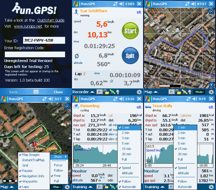
ESymetric Run.GPS Trainer UV PRO v.2.3.5.build.1910

ESymetric Run.GPS Trainer UV PRO v.2.3.5.build.1910


Overview : This allows you to define your personal training plans: import and export training plans & synchronize your training plan with Microsoft Outlook.

Allows you to create your personal training plans:
* plan your training units with the following parameters:
* sport
* time of day
* frequency (once, daily or weekly)
* distance
* duration
* average speed
* intensity
* minimum and maximum heart rate
* import and export training plans
* synchronize your training plan with Microsoft Pocket Outlook

What's new in Run.GPS Trainer UV 2.3.5 build 1910 (29-Jan-2010):
* added support for .NET Compact Framework 3.7 (e.g. on HTC Touch HD2); on some devices a "InvalidProgramException" came up when starting the application; this error is due to a bug in the Microsoft C# compiler.

Requirements : WM5, WM6

Download:  http://www.megaupload.com/?d=HSDJQAYK
Read More!

BeeLineGPS v2.0.7000

BeeLineGPS v2.0.7000


 Overview : BeeLineGPS is a high performance Pocket PC cache navigationand management software tool.

Import GPX files and manage thousands of waypoints with the advanced Waypoint Manager.View, manage and hunt geocaches with ease and confidence while having fun,a perfect paperless solution.BeeLineGPS also includes active waypoint technology where a waypoint can trigger a warning window for speed traps,safety cameras or play a sound byte while on a guided tour.Other features include waypoint averaging, altitude profiling and a comprehensive trip computer.BeeLineGPS is the ultimate GPS tool for all your geocaching and outdoor needs.

Requirements : WM5-WM6.5


Read More!

Friday, October 29, 2010

NDrive v10.1.15 for WindowsCE GenericGPS

NDrive v10.1.15 for WindowsCE GenericGPS


Requirements: PNA with WindowsCE OS
Overview: Version 10 NDrive for WindowsCE5 and WindowsCE6 GenericGPS


Read More!

Tuesday, October 26, 2010

Nike+ GPS v1.0.3

Nike+ GPS v1.0.3


Requirements: Compatible with iPhone and iPod touch. Requires iOS 4.0 or later.
Overview: The Nike+ GPS app helps you get the most out of every run by tracking where you go and motivating you to take it further.

- Download it on the go and start running anywhere. With this app in hand, track every indoor and outdoor workout easily, without a sensor.

- Record your pace, distance and run route using the iPhone’s GPS and accelerometer technology so you can focus on the road ahead, and relive your run later.

- Anytime you’re up for a challenge, push farther, faster, or longer to better reach your goals. Then celebrate your victories with fun, motivational messages from Nike’s top athletes.

- As you run, get voice feedback on how you’re doing or tap the map to see where you are. Then activate your personalized PowerSong for an extra boost.

- Quickly send each run to Nikeplus.com where you can brag to friends, join challenges, set goals and connect with the rest of the Nike+ community.

- The Nike+ GPS app was designed for the iPhone, but it’s also compatible with the iPod touch (without the mapping capabilities). Please note that continued use of GPS running in the background can dramatically decrease battery life.

- COMPATIBILITY REQUIREMENTS: The Nike+ GPS App is compatible with iPhone 3GS, iPhone 4 and iPod touch (2nd, 3rd and 4th generations) running iOS 4.0 or later.

Download:  http://www.megaupload.com/?d=E11WTWZD
Read More!

Walk Me To My Car v2.4.1

Walk Me To My Car v2.4.1


 Requirements: Compatible with iPhone 3G, iPhone 3GS, and iPhone 4. Requires iOS 4.0 or later.
Overview: After shopping, watching a nice game or attending classes suddenly you realize that you do not remember where you parked your car. The answer is Walk Me to My Car app from Mobility.

After parking, just tap the Pin Car button to record your car location in the parking lot. As soon as you are done and want to find your car tap the button Walk Me and voilà! You will be directed to your car. The phone will vibrate and alert you when your car is in sight. The app is designed for open parking lots, not indoor garages.

The app uses the iPhone 3GS compass but also works on the 3G. In older models, without GPS, the accuracy is not sufficient. There is an accuracy indicator: green, yellow and red. If it is red you should not use the app. When you are outside, it takes one or two seconds to achieve the best possible accuracy. GPS accuracy varies with landscape characteristics, geographical location and weather conditions.

After pinning your car you can adjust its location by touching and dragging the green beetle. You might use this resource if the accuracy indicator is yellow and there is a visible difference between the blue pin current location indicator and your car real position as seen on the screen. On your way back to the car the accuracy should improve along the way. So you can start walking to your car even if the accuracy indicator is yellow. Enjoy.

What's New In Version 2.4.1:
- bug fixed


Read More!

Saturday, October 23, 2010

CompeGPS TwoNav v2.1.2

CompeGPS TwoNav v2.1.2


Overview : Don't limit your mobility to just one kind of terrain. With TwoNav you can enjoy the best On-road and Off-road assistance, obtaining a complete solution to your orientation needs.

Don't limit your mobility to just one kind of terrain. With TwoNav you can enjoy the best On-road and Off-road assistance, obtaining a complete solution to your orientation needs. Use urban navigators' typical features (door-to-door navigation, next manoeuvre, etc.) beside the versatility of the CompeGPS Off-road tools (map viewing, movement stats, position reference edition, etc.). All in just one program. A user friendly interface will let you access a great diversity of functions so the software can be adapted to your needs in any situation. Wherever you are, TwoNav will help you find the best way to reach your destination efficiently and safety. TwoNav gives you the flexibility to use the most appropriate cartography for your needs. Any kind of map (topographic, orthophotos, elevation maps, etc.) may be used to obtain complete information about any terrain

General:
* Voice indication and Text (menu interface) inside the software in english, spanish, catalan, french, german, italian and portuguese
* 2D, plane 3D and real 3D view* (with terrain relief)
* Customizable on-screen data (speed, altitude, time on destination...)
* Compatible files format*:
o Maps: *.RMAP ,*.ECW,*.VMAP/*MPVF, *.IMP, *.CDEM
o Tracks: *.TRK, *.IGC, *.PLT,*.GPX
o Routes: *.RTE, *.GPX
o Waypoints: *.WPT, *.BWPT,*.LOC,*.GPX
* Up to 3 maps simultaneously on screen
* Track recording
* Possibility to overlap the road map (V-map) to topographic maps, orthophotos, etc. (not included) see example)
* Favorites manager

*More map formats can be imported and converted to these ones from CompeGPS Land/Air.

*Real 3D view works over topographic maps, so if v-map (road map) and CDEM are loaded, when activating 3D+ it only will be able to show the relief of the area but without the map information.

On-road (Vmap required):
* CompeGPS V-maps (Tele Atlas) with best accuracy and update level.
* Several ways to choose destination (address, map, historic, home...)
* Automatic route calculation (fastest/shortest)
* Turn-by-turn voice guidance

Off-road:
* Topographic maps available from a lot of countries in map shop
* Compatible with any kind of maps (topographic, orthophotos, etc.)
* Navigate to waypoint, following a track, route, etc.
* Unlimited track, route and waypoint creation and management
* Track/route altitude graphs

Content:
You can acquire TwoNav with Vmap included or only the software without maps:
* TwoNav Pocket: You will receive an email with a link to download latest version of TwoNav and a register code to activate it (valid for all updates within version 1.XX), but no maps are included.

You can acquire topographic maps or Vmaps (to access On-road functions) separately.
* TwoNav Pocket + Vmap: Vmap included depends on the zone you choose (TwoNav Pocket Iberia, Germany, France, Italy, etc.). You will receive a CD with:
o Latest version of TwoNav with license to access all updates within version (1.XX)
o Latest version of Vmap of your zone
o Elevation map (CDEM) of your zone

TwoNav 2.1.2:
New TwoNav version has been released to solve some little issues. We highlight next 2:
* ECW maps not working when file name has strange characters (like accents or ñ)
* Italy V-map border problem causing On-road malfunction. This problem doesn't require to update the map, only the software.
* Clock bug problem solved 
Requirements : WM05 or WINCE 4.2 or late

Download: http://www.megaupload.com/?d=GV717MB0
Read More!

Friday, October 22, 2010

XMAPSY v1.0.0.2

XMAPSY v1.0.0.2


Overview : This software transmits GPS-data from the FSX to a navigation program on your pocket PC. With the help of an arbitrary navigation software running on the PocketPC you can watch position, altitude and speed of your aircraft.

Requirements :
- Microsoft Flight Simulator X
- Microsoft .Net-Framework 2.0
- a pocket PC (ARM-Processor) with a
naviagtionprogram or a mapsoftware with GPS-input
- a connection(USB,WLAN or Bluetooth) between
FSX-PC and Pocket PC
- ActiveSync, if PocketPC is connected over USB


Download: http://www.megaupload.com/?d=SIP0T373
Read More!

Imagis MapaMap v6.4.12

Imagis MapaMap v6.4.12


Overview : MapaMap is a family of GPS car navigation systems. MapaMap systems
are simple and intuitive to operate, and feature the most precise
and up-to-date maps.


Download: http://www.megaupload.com/?d=LFVH9ZL1
Read More!

ESymetric Run.GPS Trainer UV PRO v.2.3.7b.build.2070

ESymetric Run.GPS Trainer UV PRO v.2.3.7b.build.2070


Overview : This allows you to define your personal training plans: import and export training plans & synchronize your training plan with Microsoft Outlook.

Allows you to create your personal training plans:
* plan your training units with the following parameters:
* sport
* time of day
* frequency (once, daily or weekly)
* distance
* duration
* average speed
* intensity
* minimum and maximum heart rate
* import and export training plans
* synchronize your training plan with Microsoft Pocket Outlook

What's new in Run.GPS Trainer UV 2.3.7b.build.2070 (07-Jul-2010):
* new sports icons
* separate version for Android 1.6 (Android market filters application though minSDK is set to 4) (Android version)
* support for Bluetooth heart rate monitor connectivity on all Android 2.0 and higher platforms (there have been Bluetooth connection problems on some platforms)

Requirements : WM5.WM6


Download: http://www.megaupload.com/?d=C4UYAIQH
Read More!

Google Maps Mobile v4.1.1

Google Maps Mobile v4.1.1

 Overview : Now you can get business locations, maps and directions while you're on the go. And it's all free.

Cruising around looking for a nearby coffee shop? Driving to that new restaurant but can't remember which street to turn right on? Now you can get business locations, maps and directions while you're on the go. And it's all free.

Real-time traffic:
See where the congestion is, and estimate delays in over 30 major US metropolitan areas.

Detailed directions:
Whether you plan to walk or drive, your route is displayed on the map itself, together with step-by-step directions.

Integrated search results:
Local business locations and contact information appear all in one place, integrated on your map.

Easily movable maps:
Interactive maps let you zoom in or out, and move in all directions so you can orient yourself visually.

Satellite imagery:
Get a bird's eye view of your desired location. (It's like you're there, we swear.)c

Change Log :
- New function Voice Search added.

Requirements :
PPC WM5, WM6, WM6.5


Read More!

JGUI LOC VISUALIZER v3.0

JGUI LOC VISUALIZER v3.0

Overview : Exporting geographic location received from some external GPS Locator (Tracker),directly to map image in your Windows Mobile phones.

If you use some kind of location tracker, or GPS locator, or phone with GPS, to save your children, car, or dog...the one which sends you an SMS messages with known geographic location,so... in this situations, LOC.VISUALIZER is the program you need.

It saves the received location(s), and displays automatically on Google Mobile Maps free program,or Tomtom Navigator, or Microsoft Live Search, in any Windows Mobile phone (both in Professional and Standard Winmo, smartphone versions).

What you need:
1. Some kind of GPS tracker, also named: locator, with function of sending SMS with location
2.1. Windows Mobile phone, with free Google Mobile Maps installed
2.2. or Windows Mobile phone, with free Microsoft Live Search installed
2.3. or Windows Mobile phone, with Tomtom Navigator installed
3. LOC.VISUALIZER installed

Requirements : WM5.WM6

Download:  http://www.megaupload.com/?d=6KZHQY61
Read More!

Joggah v1.4.0.3855

Joggah v1.4.0.3855
Overview : Running log with integrated GPS tracker.

With Joggah you always have your complete running log book with you on your mobile device. Using the integrated GPS tracker functionality you can record your running tracks straight to your log automatically. Of course you can still listen to music or place phone calls simultaneously while Joggah tracks your outdoor workout. As each running path is stored in standard KML format, they can be opened directly in Google Earth.

Here are some key features of "Joggah":

· Keeps a detailed log book of all your training exercises.
· Integrated GPS tracker records your outdoor fitness activities including distance, time, speed, pace, calories burned, and path traveled.
· Realtime display of speed and total distance covered based on GPS data.
· Simple finger based touch screen operation.
· Touch screen lock and button lock prevent unintentional operation while exercising.
· Various speed, pace, and distance units supported (miles, kilometers, etc.)
· Easily track jogging shoe mileage.
· Give it a personal touch by setting your own background picture.
· Storage of calories burned and training effect for each log book entry makes it ideal for a long term collection of the log book information from a Suunto heart rate monitor.
· GPS track is stored in standard KML format for easy viewing in Google Earth and similar applications.
· The log book is stored in convenient tab-separated-values format that allows direct opening in Microsoft Excel or other spread sheet applications.

Requirements : Windows Mobile 5/6.x, .NET Compact Framework 2.0

Download:  http://www.megaupload.com/?d=1PUV2TGS
Read More!

BeeLineGPS v2.0.15 BETA

BeeLineGPS v2.0.15 BETA
Overview : BeeLineGPS is a high performance Pocket PC cache navigation and management software tool.

Import GPX files and manage thousands of waypoints with the advanced Waypoint Manger. View, manage and hunt geocaches with ease and confidence while having fun, a perfect paperless solution. BeeLineGPS also includes active waypoint technology where a waypoint can trigger a warning window for speed traps, safety cameras or play a sound byte while on a guided tour. Other features include waypoint averaging, altitude profiling and a comprehensive trip computer. BeeLineGPS is the ultimate GPS tool for all your geocaching and outdoor needs.

v2.0.15 BETA:
Slowly I've been working on the next generation (version 2.0) of BeeLineGPS. This version will drop support for WM - 2003 to support the newer OS's from WM 5, 6.1 and 6.5. The major addition will be the use of the Microsoft GPS API. BeeLineGPS will still have the ability to connect to a GPS through a serial port, but will default to the GPS API.

Requirements : Windows Mobile 5, 6.1 and 6.5

Download:   http://www.megaupload.com/?d=XRTM0D42
Read More!

Global Navigator v5.9

Global Navigator v5.9
 Overview : Global Navigator (formerly known as Google Navigator) is a powerful and easy to use GPS navigation software.

Global Navigator (formerly known as Google Navigator) is the most powerful and easy to use GPS navigation software on your Pocket PC with: 3D GPS Navigation all over the world + Offline map and satellite image + Map range download+ 3D street view + Photo layer + GPS tracking + GSM tracking + Take photo and record video with position + Custom path drawing +Trackline saving and loading + Open trackline with Google Earth.

Designed with productivity in mind, Global Navigator offers a quick and easy way to obtain the map and location information on your Pocket PC.With the most powerful functionality on map data operation and convenient user interface.You will enjoy the fun on your Pocket PC.

Here are some key features of "Global Navigator":

· Four view mode: Map mode, Satellite mode ,Hybrid mode and Terrain mode
· Photo layer let you view images on map all over the world!
· Select map range and download all the map and satellite image automatically
· Map can rotated in all 3D angle and move in all directions like Google Earth on your pc
· Add GSM or GPS position info to photo and video that taken by camera automatically and show it in Global Navigator
· Search the up to date location and business via network
· Pick some favorites locations to appear all in map
· step-by-step voice and turn directions in GPS navigation
· 3D street view allows you to quickly and easily view and navigate high-resolution, 360 degree street level images of cities in the world
· Tracking other's GPS position in Global Navigator using the SMS tunnel,no network connection need!
· Tracking other's GSM position in Global Navigator,no GPS hardware and no network connection need!
· Save the track line and load it in Global Navigator .
· Convert track line to Google KML format and open it in Google Earth in PC
· Send the GPS position or the Selected position by SMS ,MMS and email.
· Custom path drawing and start GPS navigation.

What's new in Global Navigator 5.9:
· Bugs fixed for navigation in WVGA device
· Bugs fixed for can't get direction in some device
· Improve photo layer displaying

Requirements :
· Windows Mobile 5/6
· .NET Compact Framework 2.0

Download: http://www.megaupload.com/?d=0ZGV16Q8
Read More!